Google Maps MCPサーバー
- GitHubスター 490
- 2026年10月22日更新
Google Maps MCP Serverは、ジオコーディング、検索、ルート案内、天気のための18個のGoogle Mapsツールを、AIコーディングエージェントに提供するMCPサーバーです。
Google Maps MCPとは?
Google Maps MCP Serverは、ジオコーディング、場所の検索、ルート案内、天気など、18個のGoogle Maps Platformの機能をMCPツールとして公開します。位置情報に対応したSaaS、モバイルのコンパニオンアプリ、社内向けのエージェントワークフローを、REST呼び出しを1つずつ手書きすることなく試作・開発できます。npmで@cablate/mcp-google-mapとして配布され、stdioトランスポートで動作します。Claude CodeやCursorの隣でローカルのMCP子プロセスを動かす一般的な構成に合っています。GOOGLE_MAPS_API_KEYの指定が必要で、GOOGLE_MAPS_ENABLED_TOOLSを使えば、開発中は有効なツールを絞って最小権限で運用できます。仕様にすでに地図が必要な統合のBuildで使ってください。MVPがリモート完結の場合や、Mapsの課金を予算に組み込めない場合は見送りましょう。有効にするAPIは、Google Cloudコンソールの制限と必ず揃えてください。
- 18個のGoogle Mapsツール:ジオコーディング、検索、ルート案内、天気、関連API
- npmパッケージ @cablate/mcp-google-map v0.0.52、stdioトランスポート
- 環境変数 GOOGLE_MAPS_ENABLED_TOOLS で、一部のツールのみ、または * で全ツールを有効化
- Google CloudコンソールのGOOGLE_MAPS_API_KEYが必要です
- stdio MCPなので、ローカルのClaude CodeやCursorの設定に適しています
数字で見るGoogle Maps MCP Server
- 2026年11月9日時点のデータ(Skillselionカタログ同期)
claude mcp add --env GOOGLE_MAPS_API_KEY=YOUR_GOOGLE_MAPS_API_KEY --env GOOGLE_MAPS_ENABLED_TOOLS=YOUR_GOOGLE_MAPS_ENABLED_TOOLS google-map -- npx -y @cablate/mcp-google-mapGoogle Maps MCP Serverのバッジを追加する
このMCPサーバーがSkillselionに掲載されていることを開発者に示せます。READMEに貼り付けてください。

埋め込みコードを取得
| GitHubスター | ★ 490 |
|---|---|
| パッケージ | @cablate/mcp-google-map |
| トランスポート | STDIO |
| 認証 | 必要 |
| 最終更新 | 2026年10月22日 |
| リポジトリ | cablate/mcp-google-map ↗ |
ユースケースと機能
Google Maps MCPは何をしますか?
MCP経由の18個のGoogle Maps APIツールで、コーディングエージェントにジオコーディング、場所の検索、ルート案内、天気の機能を与えます。
Google Maps MCPはどんな人に向いていますか?
エージェントに統合作業を任せて、地図、場所、ルート案内を追加する場合に最適です。
見送ったほうがよい場合: 位置情報の要件がまったくないプロダクトや、Google CloudのAPI費用が認められていないチームには向きません。
Google Maps MCPは何を生成しますか?
エージェントが型付きのMCPツールでGoogle Mapsを呼び出すので、独自のHTTP連携コードを書かなくても、プロトタイプに実際の地理データとルート検索を組み込めます。
- エージェントから呼び出せるジオコーディング、検索、経路案内、天気の操作
- GOOGLE_MAPS_ENABLED_TOOLSで設定できるツール構成
- コードベースでの地図連携の反復を高速化
- Google MapsのMCPツールは18個
- パッケージ @cablate/mcp-google-mapのバージョンは0.0.52
- トランスポート:stdio、必須のシークレットGOOGLE_MAPS_API_KEY
Google Maps MCP ServerのREADMEには何が書かれていますか?
README.md




Give your AI agent the ability to understand the physical world —
geocode, route, search, and reason about locations.
English | 繁體中文
- 18 tools — 14 atomic + 4 composite (explore-area, plan-route, compare-places, local-rank-tracker)
- 3 modes — stdio, StreamableHTTP, standalone exec CLI
- Agent Skill — built-in skill definition teaches AI how to chain geo tools (
skills/google-maps/)
vs Google Grounding Lite
| This project | Grounding Lite | |
|---|---|---|
| Tools | 18 | 3 |
| Geocoding | Yes | No |
| Step-by-step directions | Yes | No |
| Elevation | Yes | No |
| Distance matrix | Yes | No |
| Place details | Yes | No |
| Timezone | Yes | No |
| Weather | Yes | Yes |
| Air quality | Yes | No |
| Map images | Yes | No |
| Composite tools (explore, plan, compare) | Yes | No |
| Open source | MIT | No |
| Self-hosted | Yes | Google-managed only |
| Agent Skill | Yes | No |
Quick Start
# stdio (Claude Desktop, Cursor, etc.)
npx @cablate/mcp-google-map --stdio

# exec CLI — no server needed
npx @cablate/mcp-google-map exec geocode '{"address":"Tokyo Tower"}'

# HTTP server
npx @cablate/mcp-google-map --port 3000 --apikey "YOUR_API_KEY"
Special Thanks
Special thanks to @junyinnnn for helping add support for streamablehttp.
Available Tools
| Tool | Description |
|---|---|
maps_search_nearby |
Find places near a location by type (restaurant, cafe, hotel, etc.). Supports filtering by radius, rating, and open status. |
maps_search_places |
Free-text place search (e.g., "sushi restaurants in Tokyo"). Supports location bias, rating, open-now filters. |
maps_place_details |
Get full details for a place by its place_id — reviews, phone, website, hours. Optional maxPhotos param returns photo URLs. |
maps_geocode |
Convert an address or landmark name into GPS coordinates. |
maps_reverse_geocode |
Convert GPS coordinates into a street address. |
maps_distance_matrix |
Calculate travel distances and times between multiple origins and destinations. |
maps_directions |
Get step-by-step navigation between two points with route details. |
maps_elevation |
Get elevation (meters above sea level) for geographic coordinates. |
maps_timezone |
Get timezone ID, name, UTC/DST offsets, and local time for coordinates. |
maps_weather |
Get current weather conditions or forecast — temperature, humidity, wind, UV, precipitation. |
maps_air_quality |
Get air quality index, pollutant concentrations, and health recommendations by demographic group. |
maps_static_map |
Generate a map image with markers, paths, or routes — returned inline for the user to see directly. |
maps_batch_geocode |
Geocode up to 50 addresses in one call — returns coordinates for each. |
maps_search_along_route |
Search for places along a route between two points — ranked by minimal detour time. |
| Composite Tools | |
maps_explore_area |
Explore what's around a location — searches multiple place types and gets details in one call. |
maps_plan_route |
Plan an optimized multi-stop route — uses Routes API waypoint optimization (up to 25 stops) for efficient ordering. |
maps_compare_places |
Compare places side-by-side — searches, gets details, and optionally calculates distances. |
maps_local_rank_tracker |
Track a business's local search ranking across a geographic grid — like LocalFalcon. Supports up to 3 keywords for batch scanning. Returns rank at each point, top-3 competitors, and metrics (ARP, ATRP, SoLV). |
All tools are annotated with readOnlyHint: true and destructiveHint: false — MCP clients can auto-approve these without user confirmation.
Prerequisite: Enable Places API (New) and Routes API in Google Cloud Console before using place-related and routing tools.
Installation
Method 1: stdio (Recommended for most clients)
Works with Claude Desktop, Cursor, VS Code, and any MCP client that supports stdio:
{
  "mcpServers": {
    "google-maps": {
      "command": "npx",
      "args": ["-y", "@cablate/mcp-google-map", "--stdio"],
      "env": {
        "GOOGLE_MAPS_API_KEY": "YOUR_API_KEY"
      }
    }
  }
}
Reduce context usage — If you only need a subset of tools, set GOOGLE_MAPS_ENABLED_TOOLS to limit which tools are registered:
{
  "env": {
    "GOOGLE_MAPS_API_KEY": "YOUR_API_KEY",
    "GOOGLE_MAPS_ENABLED_TOOLS": "maps_geocode,maps_directions,maps_search_places"
  }
}
Omit or set to * for all 18 tools (default).
Method 2: HTTP Server
For multi-session deployments, per-request API key isolation, or remote access:
npx @cablate/mcp-google-map --port 3000 --apikey "YOUR_API_KEY"

# Bind to all interfaces for remote access (e.g. Docker, LAN)
npx @cablate/mcp-google-map --host 0.0.0.0 --port 3000 --apikey "YOUR_API_KEY"
Then configure your MCP client:
{
  "mcpServers": {
    "google-maps": {
      "type": "http",
      "url": "http://localhost:3000/mcp"
    }
  }
}
Server Information
- Transport: stdio (
--stdio) or Streamable HTTP (default) - Tools: 18 Google Maps tools (14 atomic + 4 composite) — filterable via
GOOGLE_MAPS_ENABLED_TOOLS
CLI Exec Mode (Agent Skill)
Use tools directly without running the MCP server:
npx @cablate/mcp-google-map exec geocode '{"address":"Tokyo Tower"}'
npx @cablate/mcp-google-map exec search-places '{"query":"ramen in Tokyo"}'
All 18 tools available: geocode, reverse-geocode, search-nearby, search-places, place-details, directions, distance-matrix, elevation, timezone, weather, air-quality, static-map, batch-geocode-tool, search-along-route, explore-area, plan-route, compare-places, local-rank-tracker. See skills/google-maps/ for the agent skill definition and full parameter docs.
Batch Geocode
Geocode hundreds of addresses from a file:
npx @cablate/mcp-google-map batch-geocode -i addresses.txt -o results.json
cat addresses.txt | npx @cablate/mcp-google-map batch-geocode -i -
Input: one address per line. Output: JSON with { total, succeeded, failed, results[] }. Default concurrency: 20 parallel requests.
API Key Configuration
API keys can be provided in three ways (priority order):
HTTP Headers (Highest priority)
{
  "mcp-google-map": {
    "transport": "streamableHttp",
    "url": "http://localhost:3000/mcp",
    "headers": {
      "X-Google-Maps-API-Key": "YOUR_API_KEY"
    }
  }
}
Command Line
mcp-google-map --apikey YOUR_API_KEYEnvironment Variable (.env file or command line)
GOOGLE_MAPS_API_KEY=your_api_key_here
MCP_SERVER_PORT=3000
MCP_SERVER_HOST=0.0.0.0
Development
Local Development
# Clone the repository
git clone https://github.com/cablate/mcp-google-map.git
cd mcp-google-map

# Install dependencies
npm install

# Set up environment variables
cp .env.example .env
# Edit .env with your API key

# Build the project
npm run build

# Start the server
npm start

# Or run in development mode
npm run dev
Testing
# Run smoke tests (no API key required for basic tests)
npm test

# Run full E2E tests (requires GOOGLE_MAPS_API_KEY)
npm run test:e2e
Project Structure
src/
├── cli.ts                        # CLI entry point
├── config.ts                     # Tool registration and server config
├── index.ts                      # Package exports
├── core/
│   └── BaseMcpServer.ts          # MCP server with streamable HTTP transport
├── services/
│   ├── NewPlacesService.ts       # Google Places API (New) client
│   ├── PlacesSearcher.ts         # Service facade layer
│   ├── RoutesService.ts          # Google Routes API client (directions, distance matrix, waypoint optimization)
│   └── toolclass.ts              # Google Maps API client (geocoding, timezone, elevation, static map)
├── tools/
│   └── maps/
│       ├── searchNearby.ts       # maps_search_nearby tool
│       ├── searchPlaces.ts       # maps_search_places tool
│       ├── placeDetails.ts       # maps_place_details tool
│       ├── geocode.ts            # maps_geocode tool
│       ├── reverseGeocode.ts     # maps_reverse_geocode tool
│       ├── distanceMatrix.ts     # maps_distance_matrix tool
│       ├── directions.ts         # maps_directions tool
│       ├── elevation.ts          # maps_elevation tool
│       ├── timezone.ts           # maps_timezone tool
│       ├── weather.ts            # maps_weather tool
│       ├── airQuality.ts         # maps_air_quality tool
│       ├── staticMap.ts          # maps_static_map tool
│       ├── batchGeocode.ts       # maps_batch_geocode tool
│       ├── searchAlongRoute.ts   # maps_search_along_route tool
│       ├── exploreArea.ts        # maps_explore_area (composite)
│       ├── planRoute.ts          # maps_plan_route (composite)
│       ├── comparePlaces.ts      # maps_compare_places (composite)
│       └── localRankTracker.ts   # maps_local_rank_tracker (composite)
└── utils/
    ├── apiKeyManager.ts          # API key management
    └── requestContext.ts         # Per-request context (API key isolation)
tests/
└── smoke.test.ts                 # Smoke + E2E test suite
skills/
├── google-maps/                  # Agent Skill — how to USE the tools
│   ├── SKILL.md                  # Tool map, recipes, invocation
│   └── references/
│       ├── tools-api.md          # Tool parameters + scenario recipes
│       ├── travel-planning.md    # Travel planning methodology
│       └── local-seo.md          # Local SEO / Google Business Profile ranking analysis
└── project-docs/                 # Project Skill — how to DEVELOP/MAINTAIN
    ├── SKILL.md                  # Architecture overview + onboarding
    └── references/
        ├── architecture.md       # System design, code map, 9-file checklist
        ├── google-maps-api-guide.md  # API endpoints, pricing, gotchas
        ├── geo-domain-knowledge.md   # GIS fundamentals, Japan context
        └── decisions.md          # 10 ADRs (design decisions + rationale)
Tech Stack
- TypeScript - Type-safe development
- Node.js - Runtime environment
- @googlemaps/places - Google Places API (New) for place search and details
- Google Routes API - Directions, distance matrix, and waypoint optimization via REST
- @googlemaps/google-maps-services-js - Geocoding, timezone, elevation
- @modelcontextprotocol/sdk - MCP protocol implementation (v1.27+)
- Express.js - HTTP server framework
- Zod - Schema validation
Security
- API keys are handled server-side
- Per-session API key isolation for multi-tenant deployments
- DNS rebinding protection available for production
- Input validation using Zod schemas
For enterprise security reviews, see Security Assessment Clarifications — a 23-item checklist covering licensing, data protection, credential management, tool contamination, and AI agent execution environment verification.
To report a vulnerability, see SECURITY.md.
Roadmap
Recent Additions
| Tool / Feature | What it unlocks | Status |
|---|---|---|
maps_static_map |
Map images with pins/routes — multimodal AI can "see" the map | Done |
maps_air_quality |
AQI, pollutants — health-aware travel, outdoor planning | Done |
maps_batch_geocode |
Geocode up to 50 addresses in one call — data enrichment | Done |
maps_search_along_route |
Find places along a route ranked by detour time — trip planning | Done |
maps_explore_area |
One-call neighborhood overview (composite) | Done |
maps_plan_route |
Optimized multi-stop itinerary (composite) | Done |
maps_compare_places |
Side-by-side place comparison (composite) | Done |
maps_local_rank_tracker |
Geographic grid rank tracking — local SEO analysis (composite) | Done |
GOOGLE_MAPS_ENABLED_TOOLS |
Filter tools to reduce context usage | Done |
Planned
| Feature | What it unlocks | Status |
|---|---|---|
maps_place_photo |
Place photos for multimodal AI — "see" the restaurant ambiance | Planned |
| Language parameter | Multi-language responses (ISO 639-1) across all tools | Planned |
| MCP Prompt Templates | /travel-planner, /neighborhood-scout slash commands in Claude Desktop |
Planned |
| Geo-Reasoning Benchmark | 10-scenario test suite measuring LLM geospatial reasoning accuracy | Research |
Use Cases We're Building Toward
These are the real-world scenarios driving our tool decisions:
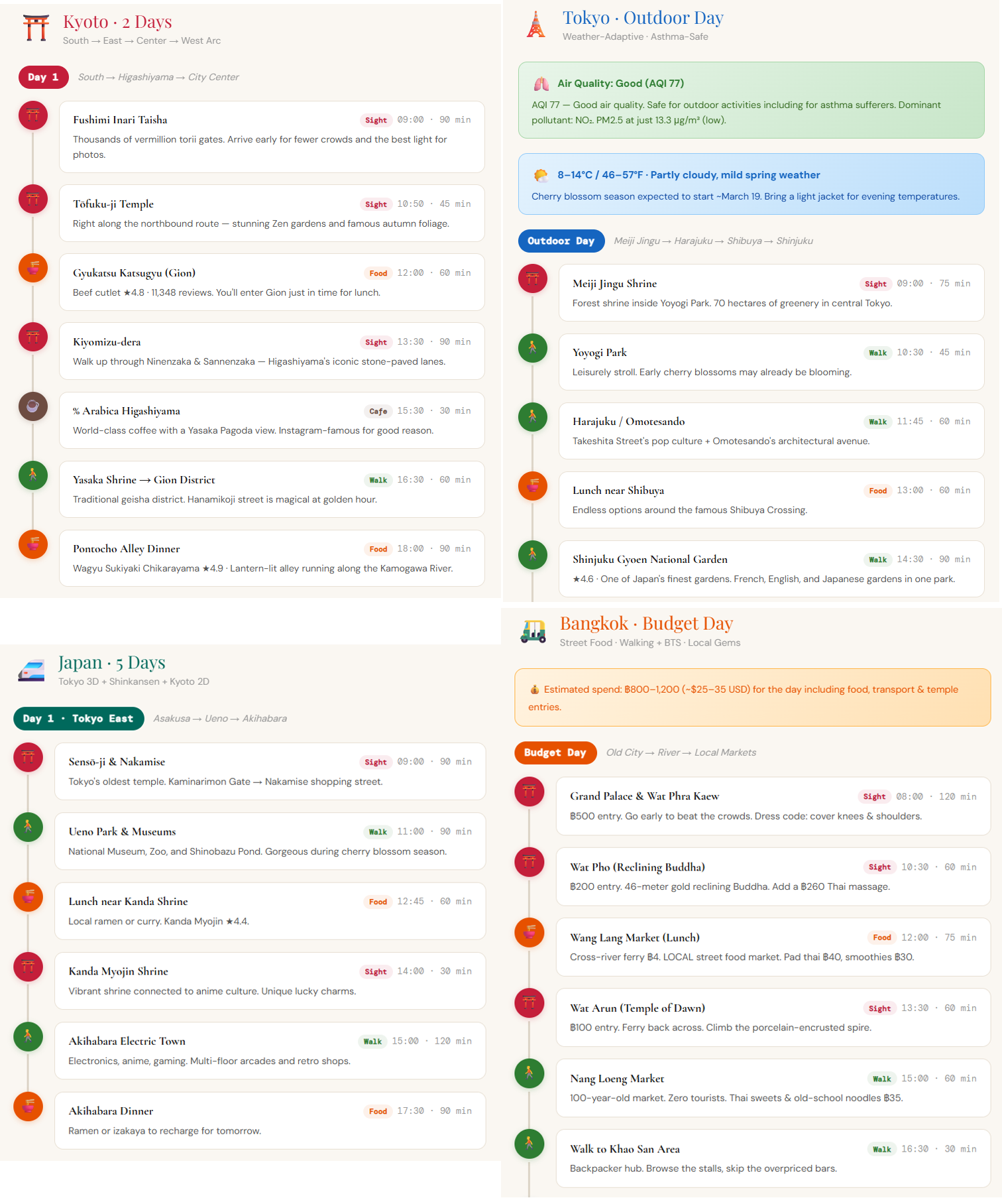
- Travel planning — "Plan a day trip in Tokyo" (geocode → search → directions → weather)
- Real estate analysis — "Analyze this neighborhood: schools, commute, flood risk" (search-nearby × N + elevation + distance-matrix)
- Logistics optimization — "Route these 12 deliveries efficiently from the warehouse" (plan-route)
- Field sales — "Visit 6 clients in Chicago, minimize drive time, find lunch spots" (plan-route + search-nearby)
- Disaster response — "Nearest open hospitals? Am I in a flood zone?" (search-nearby + elevation)
- Content creation — "Top 5 neighborhoods in Austin with restaurant density and airport distance" (explore-area + distance-matrix)
- Accessibility — "Wheelchair-accessible restaurants, avoid steep routes" (search-nearby + place-details + elevation)
- Local SEO — "Audit my restaurant's ranking vs competitors within 1km" (search-places + compare-places + explore-area)
Changelog
See CHANGELOG.md for version history.
License
MIT
Contributing
Community participation and contributions are welcome! Please read CONTRIBUTING.md for development setup, coding guidelines, and the pull request process.
- Submit Issues: Report bugs or provide suggestions
- Create Pull Requests: Submit code improvements
- Documentation: Help improve documentation
Contact
- Email: reahtuoo310109@gmail.com
- GitHub: CabLate
Star History
GitHubスター順に並べたClaude Code MCPサーバーの一覧はこちらです。
Google Maps MCPに関連するMCPサーバーは?
Google Maps MCP Serverは類似ツールとどう違いますか?
MCP経由のGoogle Maps APIブリッジです。MCPレジストリやメモリレイヤーではありません。
Google Maps MCPのよくある質問
Google Maps MCPはどんな人向けですか?
Claude Code、Cursor、そのほかstdioのMCPクライアントを使い、アプリにGoogle Maps機能を実装する開発者向けです。
Google Maps MCPはどんなときに使うべきですか?
仕様でジオコーディング、場所の検索、ルート案内、Google Maps Platformによる天気情報が必要な、統合のBuild段階で使います。
Google Maps MCPをエージェントに追加するにはどうすればよいですか?
@cablate/mcp-google-mapをインストールし、GOOGLE_MAPS_API_KEY(必要ならGOOGLE_MAPS_ENABLED_TOOLSも)を設定して、GitHubのcablate/mcp-google-mapのドキュメントに従い、stdioサーバーをMCPクライアントに登録します。